
Dr Myo Myo Khine
ဒေါက်တာ မျိုးမျိုးခိုင်
Position : Professor (Head)
Degree : B.A, M.A, Ph.D
Other Information : Diploma in Global English, Diploma in GIS, Training (Thailand), Rectors Forum (China), Workshop (Thailand)
Geography
Dr Soe Soe Khin ဒေါက်တာ စိုးစိုးခင်Position : Professor
Degree : B.A (Hons) , M.A, Ph.D
Other Information: Diploma in Global English, Diploma in GISDr Khin Thaw Tar ဒေါက်တာ ခင်သော်တာPosition : Professor
Degree : B.A, M.A,, Ph.D
Other Information: Diploma in Business Law, Diploma in GIS
Teacher list
| Sr.No | Department | Name | Position | Education | Thesis Title | Field Of Specialization | Current Research Project | Email/Gmail |
| 1 | Geography | Dr Myo Myo Khine | Professor (Head) | Ph.D | Geographical assessment of Road Infrastructure and Landuse changes in Mawlamyine city | Human Geography | – | [email protected] |
| 2 | Geography | Dr Khin Thaw Tar | Professor | Ph.D | Spatial Analysis of Housing Types in U Boat Taw Quarter of Aungmyeyzan Township | Human Geography | – | [email protected] |
| 3 | Geography | Dr Soe Soe Khin | Professor | Ph.D | Housing Developing in East Yangon District | Human Geography | – | [email protected] |
| 4 | Geography | Daw Aye Aye Kyu | Associate Professor | M.A | The Agricultural Land Utilization in Yamethin Township, Mandalay Division | Human Geography | – | [email protected] |
| 5 | Geography | Daw Cho Win Nwe | Associate Professor | M.A | The Geographical Study of Population and Settlement in Dalla Township | Population Geography | – | [email protected] |
| 6 | Geography | Daw Wai Mon Thaung | Associate Professor | M.A | Assessment on Agricultural cultivation in Myin Mu Township, Sagaing Division | Human Geography | – | [email protected] |
| 7 | Geography | Daw Mar Mar Cho | Associate Professor | M.A | Gographical Study on Urban Land Use of Hlaingtharyar Township | Human Geography | – | [email protected] |
| 8 | Geography | Daw Khine Khine Tun | Lecturer | M.A | Climate of the Transitional Zone between the Dry Zone of Central Myanmar and Its Surrounding Wet Zone | Climatology | – | [email protected] |
| 9 | Geography | U Kyi Aye | Lecturer | M.A | General Land -use of Myoma Wards in Dagon Myothit (South) Township | Human Geography | – | [email protected] |
| 10 | Geography | Daw Nyein Win Kyaw | Lecturer | M.A | Film and Video Industry of Lower Myanmar | Human Geography | – | [email protected] |
| 11 | Geography | Daw Htay Htay Yee | Lecturer | M.A | Economic Geography of Gyobingauk | Economic Geography | – | [email protected] |
| 12 | Geography | Daw Swe Yi Khaing | Lecturer | M.A (Honous) | General Landuse of South Okkalapa Township | Human Geography | – | [email protected] |
| 13 | Geography | Daw Soe Thida | Lecturer | M.A | General Landuse of Word No.(65) in Dagon Myothit (South) Township | Physical Geography | – | – |
| 14 | Geography | U Zaw Lin | Tutor | M.A | Population of distribution in Pauktaw Township | Human Geography | – | [email protected] |
| 15 | Geography | Daw Khaing Moe Aye | Tutor | M.A | Spatial Distribution of Outbreaking on Seasonal Diseases in Yenanchaung Township | Human Geography | – | [email protected] |
| 16 | Geography | Daw Su Phyo Paing | Tutor | M.A | A Geographical Analysis on Spatial Variation of Groundwater Quality of Yekyi Township of Ayeyarwaddy Region | Physical Geography | – | [email protected] |
| 17 | Geography | Daw May Wathone Zaw | Tutor | M.A | A Geographlcal Study of Agriculture in Kyaunggon Township | Agricultural Geography | – | [email protected] |
| 18 | Geography | Daw Nan Wai Hlaing | Tutor | M.A | Monsoon Paddy Cultivation of Hinthada Township | Agricultural Geography | – | [email protected] |
| 19 | Geography | Daw Khin Thu Thu Aung | Tutor | M.A | A Geographical Analysis on Spatial Distribution of Basic Education Schools in Hinthada Town | Human Geography | – | [email protected] |
| 20 | Geography | U Min Maw Zin | Tutor | M.A | Channel Morphometry Changes of Shwegyin Creek in Shwegyin Township (Bago East) | Physical Geography | – | [email protected] |
| 21 | Geography | Daw Mya Kay Khaing | Tutor | M.A | Role of irrigation in Crop Cultivation and Production; A comparative study of River Pumping and Tube Well irrigation in Myinmu Township | Human Geography | – | [email protected] |
Programmes Offered
- B.A. / B.A. (Hons) in Geography
- M.A. and M.Res. in Geography
Curriculum
B.A. in Geography
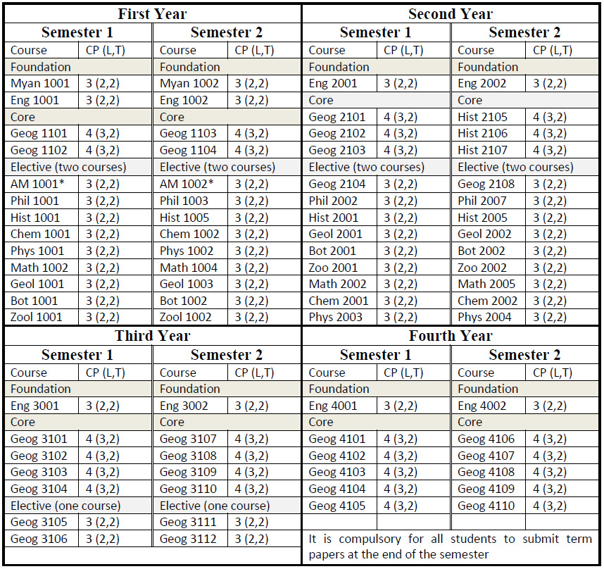
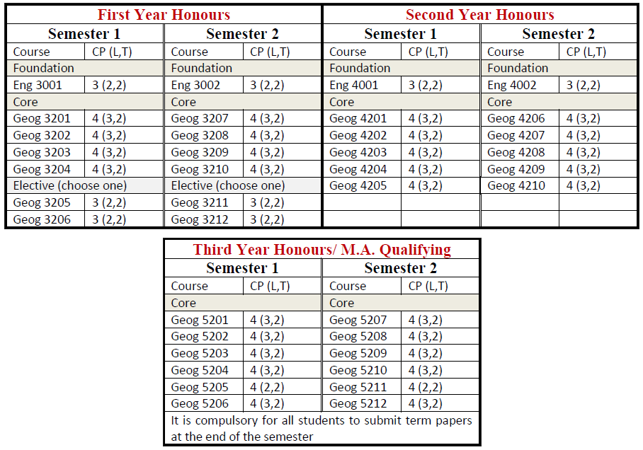
B.A. (Honours) in Geography
Students who passed second year with GPA ≥ 4 are eligible to attend B.A. (Honours) classes for three more years. After finished successfully, they are earned B.A. (Hons:) degree majoring in Geography.
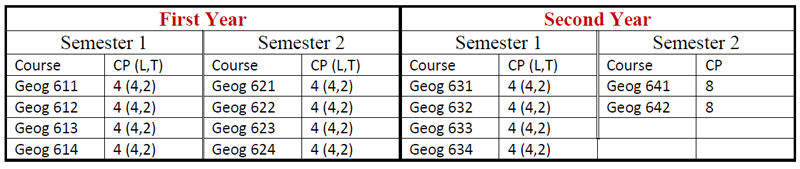
M.A. in Geography
Course Descriptions
This module first deals with the study of landforms and lithosphere in and outside the earth’s surface, and layers in the earth’s crust. They are (a) the sima or the lower layer, and (b) the sial or the upper layer. It studies landslide, weathering and types of weathering. Students, studying types of weathering, will be able to observe how physical or mechanical weathering and chemical weathering shape the landscape on the earth surface. This module then studies major stream and all its tributaries which make up drainage system and drainage basin. It focuses on the study of sand dunes which are certainly the most spectacular features of wind deposition. Moreover, students will be able to extend their knowledge of geographical processes such as how loess originated, how Alpine glaciers and ocean currents flow and how rock types occur on the earth surface.
This module consists of measurements of Angle and Direction of a location, and determination of a location. It provides students with the exercises. It will help then to understand the direction of four cardinal points and its subdivision for example, North, South, East and West. It aims to realize the bearings and azimuths according to the magnetic and grid declination. Students will be able to extend the knowledge of determination of a location with the calculation and drawing of scale and plan map. This chapter will help to know the definition of scale, type of scales and conversion of scale. So students will be able to observe the scale is essentially a ratio either expressed in words and in different units or expressed as a fraction with a numerator of 1. Moreover, students, studying Statistical Representation by Graphs and Maps, will be able to study the various methods and graphs for illustrating statistical data and figures easily. Especially, in the study of Economic geography it is very helpful to illustrate diagrammatically actual data or figures for the production of a particular commodity. There are eight methods used in Economic Geography. The module will focus on the contrast between semi-log graph and Arithmetic graph. By using the semi-log graph students will be able to get the following information (1) rates of change; (2) trends of different items; (3) detail of low value and the generalization of high values (4) Percentage change (5) possible prediction through trends; and (6) a wide range of values.
This module aims at the study of four major divisions of our earth system and the interactions between the components of each of these subsystems which create our physical landscape. Students will be able to know what causes the variations in the atmospheric elements and the control variables on these variations. It focuses on how sun’s energy loses, monsoon winds shift from one season to next, the water circulates from one part of the general earth system to another adiabatic cooling process takes place and cyclone and anticyclone occur. It concentrates on the work of Koppen’s classification for climatic system.
This module first deals with the study of Methods of illustrating Distribution Graphically. It aims to acquaint students with the major works to identify the methods for representing the quantitative data. Distribution methods are useful in Economic and Regional Geography. There are three main methods (a) unit dot method (b) shading method and (c) method of square or circles. It deals with the drawing of isolines and weather maps. Students will be able to get the knowledge of construction some quantitative areal map approximately for certain particular purpose by using isolines, which indicate equal value by lines such as isopleths, contour lines, isotherms, isohyets and Isobars. This module provides students with an understanding of weather forecasting that represent weather associated feature such as the occurrence of storm and rain and the speed of wind etc. It also deals with the Koppen system of climatic classification and interpretation of climatic data. Moreover, students will be able to learn how to define the boundaries of the world’s climatic groups and types of temperature and rainfall. It focuses on the works concerned with the determination of latitude and longitude, and time and astronomical co-ordinates. Students will have then to learn to develop a means of determining and descripting position or relative location of any place on the earth’s surface and to gain the knowledge of calculation of time for each local area in relation to the solar time.
This Module consists of physical, cultural and socio-economic bases of Southeast Asian Countries. It includes geographic account of nine nations. It offers physical setting of Southeast Asian Countries. Students will be able to acquire the knowledge of two main parts of Southeast Asia such as Mainland and Archipelagic. This module studies the interesting fact that Indian and Chinese Cultural influence on other Southeast Asian Countries. When students study ASEAN population, they can know the distribution of population and different population density of each country. By studying this module, students will be able to extend their knowledge of ASEAN countries. It focuses on Regional Geography, Physical Geography, Economic Geography and Socio-economic Geography of the countries.
This module first deals with the study of Myanmar Naing Ngan which has a unique physical setting with neighbouring countries. Moreover students will be able to know climatic condition of Myanmar Naing Ngan. It also offers the study of wide varieties of flora and fauna, abundant natural resources, culture and wide range of economic activity of the country. This module then studies the transformation from agricultural economy to agro-based industrial economy. It contributes to understand the basic geographic factor that determines the distribution and density of population. This module focuses on the study of geographical bases of States and Region. After studying this module the students will come to realize the regional geography of the Republic of the Union of Myanmar.
This module first deals with the study of human actions and environmental impacts. Moreover, this module concerns with the nature, scope and development of human activities, urban development in a global phenomena, population characteristics, distribution of world population, human cultural of the world and the political economy of culture. There are two mains approaches such as the study of man relationship with the environment and the study of man’s use and organization of space. This module aims to identify and analyze the form and nature of the “ecological system” and “spatial system”. Students can learn urban structure of the world, urban change, urban environment matters, planning and management. Besides this module offers students understand the human behaviors and its location implication. Students, studying human behaviors, will be able to observe how human actions impact and change in the environment. And then students can study environmental problems what is happening in the world. By studying human geography, students can be able to know how the human activities influence upon the location of economic activities, pattern of cultural diffusion, and the degree of political integration.
This course introduces definition and criteria of developing countries. This course begins with an introductory presentation of world’s developing countries such as general configuration of the countries. This course provides knowledge of regional geography of developing countries. Students will be able to know several different physical basis and human basis. Students, studying geography of developing countries, will acquire the knowledge of a nation such as historical background, location, size, shape, boundaries, topography, climate, soil, vegetation, population, race and religion. It aims to notice these countries’ diversified economic sectors. Moreover, it deals with the study of Socio-economic status of world’s developing countries in Asia, Middle East, Central America, South America and Africa.
Students will come to get basic knowledge to obtain accurate information about objects or environment in surveying, and to construct graticules network (longitude and latitudes) in map projection after studying this module. Objectives of survey are: (1) to learn the art of making relatively large measurements with a maximum of accuracy and with a minimum expenditure of time and labor ,(2) to study the natural and man-made features , particularly their location, shapes and relative singes on maps produced on suitable scale, and (3) to learn various types of survey depending upon instruments used , the method of operation adopted in relation to small areas of the earth’s surface or with large areas of the earth’s surface. As a basic course pacing method survey, surveying by chain or tape, prismatic compass survey and aerial survey are included in this module. Students, studying of map projection, will be able to observe the idea of constructing a gratitude network used in cartography, doing the necessary calculations and then drawing of the network. In this module types and cases of projection, Zenithal projections, Conic projections, and Cylindrical projections are basically recommended.
This module first deals with the study of remote sensing techniques. Students will be able to get the knowledge of remote sensing as a tool for research works. It focuses on study of the electromagnetic characteristic and interaction of this energy and the all matters on the earth surface. This module offers students to get the idea for choosing remote sensing data based on the sensor- platforms and image data characteristics. This module traces the manipulation of remotely sensed data for visualizing on computer monitor as grey scale or color composite image. It provides students which methods should be used for smoothing and sharpening image by digital filter operation. This module focuses the digital image classification method for identifying and classifying features from image data. Students will have ability to prepare image classification. Moreover, students will know about the classification algorithms (classifiers) for performing image classification and accuracy.
This module examines the interactions between people and their environments. The field of environmental geography emphasizes the role of environmental concerns in all our activities. This module integrates the natural sciences with environmental ethics, environmental economics, environmental law and planning. Students can study the interactions between people and their environments in both how they alter those environments through human activities and vice visa. Moreover this module deals with management and sustainability of environment, environmental hazard, pollution, and toxin in the environment, people and environment, world resources and resources management and development. By studying this module, students can be able to realize the effects of air pollutions and water pollutions in our surrounding. Besides students will be able to understand about environmental problems and can be able to aware the methods of maintenance and management to the environment. Environmental geography provides students the best strategies for controlling to the environment.
This module introduces definition and criteria of developed countries. It begins with an introductory presentation of world’s developed countries. This module provides knowledge of regional geography of developed countries. It then studies several different physical basis, economic basis and human basis. This module offers students to acquire the knowledge of a nation such as historical background, location, size, shape, boundaries, topography, climate, soil, vegetation, population, race and religion. Moreover, it focuses on the notice of these countries’ diversified economic sectors. It will offer the study of Socio-economic status of world’s developed countries such as United States of America, United Kingdom, Germany, France and Japan.
This module has two parts. One part is about Cartography and the other is about Map Reading. Cartography is about map making. Map Reading describes about nature of maps and uses of maps. This module aims at to know how maps came to be made and used. Students will be able to understand the different kinds of maps, the requirements for the production of proper maps, the merits and demerits of different maps, and the different scales for different kinds of map. On the other hand, Topographic Map Reading offers students to know history of maps, to understand index map of Myanmar, to realize basic principles of map reading, to get the knowledge of representation of relief, to promote the ability of map interpretation, to analyze the significance of cultural elements, to know about economic elements, to get the practice of drawing cross section systematically, and to examine the selected topographic maps.
This module starts with what GIS is. Students will be able to know the importance of GIS which is a computerized tool for solving geographic problems and is a spatial decision support system. It also deals with the study of information systems that keep track not only of events, activities and things but also of where there events, activities and things happen or exist. Students will be able to define the characteristics of coordinated system. This module offers the basic method of representing graphic entities on a map using raster, vector and quadtree systems and their advantages and disadvantages. Database model provides students with useful expression for designing a database that performs efficiently, certain correct information and easy to maintain and extend. This course provides the ability to link spatial data (location) with information (facts and figures). It aims to acquaint students with the major works of spatial analysis. It also links a network to solving location-allocation problems and transportation planning modeling. Moreover, it will provide students with the main ideas for displaying maps, graphs and tabular information based on a variety of output media and cartographic functions.
This module first deals with the study of definition, scope and approaches of political geography. This module offers students to understand the changing process of political geography. It traces the location, size, shape and relief of the nations. This module focuses on the importance of mountain states and mountain passes. It also describes how relief influences on boundary location. Students will be able to know the importance of climate to be a powerful nation. This module comprehends the assets and deficits of climatic homogeneity and climatic complexity. It also focuses on the important on the rivers, lakes, swamps and canals from the view point of the politics. This module also deals with the significance of islands and peninsulas. It aims to acquaint students with the explanation of the real meaning and concept of frontiers, buffer zones and boundaries.
This module provides the significance of the structure of population and population policies. This module deals with the core areas and capitals which are important for political role. It will study resources, foods and minerals. This module provides the international trade policies and focuses on free ports and free zones. This module highlights the evolution of the law of the sea and zones of territorial sea. Students will be able to extend their knowledge with the works of geographers who explained some specific theories in political geography. Students, studying this module, will be able to observe the important forces that affect the contemporary decisions on the national and international scale. It describes how globalization has been shifting world policy which is away from its central premise of sovereign statehood. By studying this module, the students will be able to know the main ideas and concepts of the political geography.
This module first deals with the studying of the quantitative aerial maps. It is fundamental to study about the determination of Latitude and Longitude that refer to geographical position. Students will be able to observe the directions of cardinal points and its subdivisions, the bearings and azimuths according to the magnetic and gird declinations, and the definitions of scale, types of scales and conversion of scales. Moreover, students will have to do practical exercises to construct the plan maps according to the measurements of scale diagram and compass directions. This module studies various methods and graphs for illustrating statistical data and figures. Students will be able to know the instinct judgment on the Graphical Representation methods, choose the different types of cycle according to the statistical data and identify the methods for representing the quantitative data.
This module intends to obtain information about surveying and photo interpretation and stereoscopic viewing, elements of photogrammetry and Aerial Photo Interpretation. It consists of two parts. Part one is about surveying such as methods of survey, usages of instruments in surveying. Part two describes about the methods of viewing stereoscopes and characteristics of a photograph, elements of photogrammentry and basic to photo interpretation. The main goal of the surveys done on the earth’s surface is to represent the natural and man-mate features, particularly their locations, shapes and relative sizes on maps produced on suitable scale. Students will acquire the knowledge of common use of photogammetry in the preparation of topographic maps and mapping in other sciences. Students will be able to extend their knowledge of Aerial Photo Interpretation by studying the geometric relation of Aerial photograph and characteristics and types of aerial photographs and photo scale, displacement, parallax, flight scale, displacement, parallax, flight line and shadow. Moreover it concentrates on the study of how to prepare flight planning and how to acquire high quality aerial photography.
This module offers students to understand basic concepts, principles and processes of human geography in general, cultural geography in particular. This module traces man’s relationship with the environment and man’s use and organization of space. It studies different cultures and different world problems. This module will help students to have basic logical thinking to the problems of development of human landscape. Students will be able to observe the basic concepts, principles and processes related to population, culture and cultural landscape.
This module offers students to understand the spatial distribution of population and variation of culture. This module traces to provide knowledge of human response to resources. Students will be able to observe factors shaping the cultural landscape. It will help students improve skills in observation, recognition and evaluation of cultural landscape. Students will be able to observe the awareness of respect and responsibility for the quality of the environment. This module focuses on an understanding of themes and ideas. This module traces human behavior that is linked to the organization and utilization of space. It concentrates on regularities of behaviour and of the spatial patterns they create.
The soil geography aims at developing student’s ability to regent the place of soils in the environment as vital factors in the life of most organisms. Students will be able to extend their knowledge of the development of soil science. This module then studies a variety of approaches to analyse the soil components which are mainly composed of organic and inorganic matters. The soil geography provides students with useful expression to analyze the properties of soil which are resulted by the interaction of the factor of soil formation. Students will be able to extent their knowledge of soil geography, being selected and presented through a thematic approach. It examines the physical properties of soil. It also traces to examine the chemical properties of soil for avalibality of nutrients to plants and thereby to modify the physical conditions of soil. This module also deals with the process of soil erosion or destruction of soil.
This module aims to study the definition, field and scope of settlement, and describes temporary to permanent settlement. It studies about the relationship between climate and settlement. This module offers students to understand the criteria used for classification. Students will be able to observe the types of settlement, the nature and development of rural settlement, and the general patterns of rural settlement. This module deals with the ratio of rural and urban settlement. Students will be able to observe geographical factors influenced the settlement in hilly areas, Shan highland, and plain areas. This module studies the features and forms of compact and linear or elongated villages. This module provides students to understand changing patterns of towns and classification of towns. This module then concentrates on the functions and types of modern cities, distinguishing features of a city, the distribution of cities and urban population and urban settlement problems. This module focuses on the knowledge of the theory of settlement that can be used in discussing and tackling current critical social issues.
The course first deals with definitions, approaches and scope of economic geography with the attention to facts and theory. This module centres on the studying of the activity components of economic geography and the reasons of the locational characteristics of the economic activities. It includes the detail explanation of six major economic activities which help students to understand the importance of economic geography. Students will be able to know the geographical concepts of “principle of comparative territorial advantage” scale economies, and “supply and demand”. It aims to acquaint with the major work of Raymand E. Murphy, Richard S. Thoman, and John W. Alexandef. This module studies the effect of transportation on locational choice of any economic activity. It also deals with the study of extractive activities.
This module first deals with the study of the statistical data and the construction of frequency table with the statistical data. It provides students with the drawing histogram, frequency distribution curve and cumulative frequency curve or ogive to observe target population. This module focuses on the study of systematic sampling or stratified sampling, three means, types of Deviation and methods of correlation. Moreover, students will have to learn to draw the regression lines and trend lines on a graph as practical work. This module concentrates on the discussion of deviation from the trend lines.
This module aims at developing student’s ability to know regional concept. This module then studies a variety of approaches to examine the latest conditions of world’s population pattern. Students will be able to extend their knowledge of the measures of developments. It provides students with useful expression to know the region and subregions of North America, Sub Saharan Africa, North Africa, Southwest Asia, South Asia, The Australia realm, the Pacific realm. It also focuses on human resource development. This module deals with the influential condition on global political and economy. It traces to study human factors on development. This module provides students with useful expression to realize the diverse natural environment and cultural varieties. It explains the climatic extreme and wealthy of natural resources in subregions. This module deals with the human environments of former USSR and current subregions. This module also deals with the study the region’s diverse and natural environments. It provides the great variety of natural landscapes in regions. Students will be able to understand the major internal problems in the countries of subregions and the relationship between economic growth and environmental problems.
This module first deals with the study on investigate the geographical distribution of plants on the earth. Students will be able to extend their knowledge of the study on floristic approach and ecological approach. This module then studies the origination of organisms from aquatic ancestors. It provides students with useful expression to explain the organic variation in comparison between the land and ocean environment in geological time amend space. This module then studies a variety of approaches to understand the habitat factors that exert a special influence upon the life of the plant. This module also deals with the types of plants according to their water requirements in different types of habitats. It provides to notice the various types of natural vegetations. It traces the distinctive characteristics of the forest formations. This module studies the effects of environmental selection on animal distribution.
This module first deals with the study of history and evolution, location, morphology and classification of cities and towns etc. This module aims to understand how cities are structured and organized and the urban economy grows or declines and what are the main economic functions of a city. Students will be able to get the knowledge of major problems and challenges that are facing such as the decay of central areas congestion and suburbanization and urbanization, and basic urban planning methods and concepts. This module deals with the process of urbanization evolved from the shift of rural population to urban areas, shift of agriculturists to non agricultural occupations and change of old traditional society’s replacement with a modern society. This module studies ‘The World Cities or Global Cities’. The students will be able to extend their knowledge with the studying of the commanding nodes of the global system-London, New York and Tokyo, old cities as centres of artistic, scientific and technological innovation of culture and education. This module observes the movement of people, goods, ideas that constitute the dynamics of the urban systems and the system’s lifeblood. This module focuses on urban impacts such as climate change, air pollution, smog, hydrological effects and water pollution, waste and garbage and noise pollution.
The course studies aspect of economic geography, the development of its thought and research methods, the relationship between man and physical environments through studying agriculture, mineral and industrial resources. This module studies the bases of agricultural location with the concepts of J.H. Von Thunen (1826). Students will be able to observe the major locational determinant of the type of agriculture and characteristics of the firm. This module offers students the understanding of bases of manufacturing location and the basic components in industrial location. Students will be able to observe the geographical concepts such as “horizontal integration”, “vertical integration” and “agglomeration economies”. It will also offer students with the major work of Alfred Weber (A Simplified, transportation-based location model).
This module focuses on the study of the arithmetic average, the standard deviation, Normal Frequency Distribution and the probability of occurrences. This module aims at to study a statement of characteristics that are relevant to the total population, or at least to the target population (e.g. population, population standard deviation). It also studies the relation between sample statistics and true parameters. Moreover, this module concentrates on the quantitative analysis to compare one set of values with one or more other sets.
This module aims at developing student’s ability to understand the approaches of Cultural Geography. This module deals with the study on biological differences between human beings. It provides students with useful expression to the study of population distribution. Student will be able to extend their knowledge of cultural geography being selected and presented through a thematic approach. It aims to realize the cultural region and portion of the earth’s surface occupied by population. It provides the set of cultural region showing culture complex and landscapes. This module also deals with the structure of culture and cultural processes. It focuses on the heritage of many eras of natural evolution and generations of human efforts. This module also deals with the dual processes of development and diffusion. This module traces a location for activities, the level of interaction between locations and location potential for development.
This module first deals with the study of landforms. This module reviews how the philosophical approach to the study of geomorphology has changed with the recent development of geomorphic thinking during the World War II. This module analyzes process and the resulting landforms. This module provides students to understand endogenic processes. Students will be able to learn how chemical weathering produce soil. This module aims to appraise students with soils and important elements in reconstructing geomorphologic history and physical geomorphology. It then analyses three pedogenic regimes – podzolization, laterization, and calcification. This module will help students to study how the process of physical weathering modifies the existing landforms into unconsolidated debris and small particles. It also deals with the evolution of slope profile. Students will be able to acquire the knowledge of statistical balance among the spatial characteristics of river networks and the watershed areas. This module will help students evaluate the drainage basin as primary units for systematic analysis of geomorphology. It examines morphometry, the type of channel pattern and the longitudinal profiles.
The students will come to understand and to become better acquainted with the basic element and various factors and events of political geography after studying this module. This module deals with the study of physical elements of political geography such as location, size, shape, boundaries, relief and climate, the main methods of expressing the geographical location of an area, and about the importance of strategic location. Moreover, it focuses on the importance of size, shape, relief and climate to become a power nation. This module will have students to understand the importance of river, lakes and cannels from the view point of politics. It traces islands and peninsulas, boundaries and the effects of human elements upon them.
This module intends to be familiar with the Geography of Myanmar. It consists of physical bases, economic bases and socio-economic geography of the Republic of the Union of Myanmar. This module gives knowledge for students to know the geographic locations, and the neighboring countries, to understand the paleogeography of Myanmar, to realize the physiographic regions, drainage pattern, climate, soils, forests and extraction of minerals of Myanmar. This module deals with socio-economic conditions of Myanmar. This course focuses on the important types of agriculture and the irrigation projects. This module consists of basic geographic factors that determine the distribution and density of population.
This module offers students to understand how the agricultural activities are operating. Students will be able to observe that agriculture and geographical factors are relating to each other. Bases of agricultural location aim at fundamental concepts of agricultural geography. This module studies primary activities, subsistence economic system; modification of subsistence agricultural systems, advanced economic systems, commercial economies, intensive commercial agriculture and agricultural regions.
This module focuses on the study of geospatial technology and geospatial analysis. This course concentrates on the fundamental concepts of geospatial analysis and how geospatial technologies are used to solve real-world problems across both space and time. Students will be able to learn the basic techniques of mapping, GPS (global positioning system), GIS (Geographic Information Systems), spatial analysis, cartography, and remote sensing. This course will cover to understand geospatial data models, displaying geospatial data, creating geospatial data and spatial statistical analysis. Students will be able to apply these techniques in their career. By the end of this course, students will be knowledgeable of and familiar with the programs. This GIS technology can be used for many different applications, including scientific investigations, natural resource management, environmental impact assessment, urban planning, cartography, criminology, hazards, marketing, and the logistics of location. This course provides themes such as Ecology, Social and Economic Geography, Environmental pollution, Climate change, Deforestation, Urbanization, Mountain development and Rual development.
This module first deals with the study of the topography of floodplains, the knowledge of terraces, the characteristics of piedmont regions and the formation of deltas. It focuses on the study of geomorphic features associated with erosional and depositional processes. It offers students the knowledge that how erosional features develop. This module focuses on how glaciers form and how they move. This module also focuses on the study of the landforms developed in specific regions by the glacial erosion and deposition. The students will be able to study the formation of ice-wedge polygons, thermoskarst, and pingo. This module aims to acquire the knowledge of karst hydrology and the most common karst landforms. It then discusses about the barrier islands and the reefs which are common in the coastal regions of the tropics.
This module will enable the students to become better acquainted with the basic elements of political Geography. It deals with the study of the resources and power, and economic strength of states. Students will be able to observe that the importance of self-sufficient of food stuffs is a primary preoccupation of states. This module then studies strategic metals, manufacturing industry, transportation and trade components. It traces the developments of law of the sea.
This module aims to study the outstanding factors about States and Regions. It provides students to understand the physical background, to be aware of human resources, to have insight on economy and to focus the importance of transportation. This course deals with geographical accounting on the States, Regions and the Union Territories of the Republic of the Union of Myanmar. This module studies geographical factors of Chin, Rakhine, Kachin, Shan, Kayah, Kayin and Mon States, and then Sagaing, Mandalay, Magway, Bago, Ayeyarwady, Yangon and Tanintharyi Divisions and Nay Pyi Taw (Union Territories). It improves student’s ability to understand physical and socio-economic geography of States and Divisions of Myanmar.
Manufacturing Geography offers the students to understand how the manufacture activities of the world are operating. This module studies how manufacture activities are distributing and relating to geographical factors. It focuses on the development of industrial mode of life and bases of manufacturing location and types of manufacturing. Students will be able to extend their knowledge with the study of Industrial Location Theories. This module then studies manufacturing pattern; market-oriented patterns, raw material-oriented patterns and high-tech patterns. It provides students to learn major manufacturing regions of the world such as Europe, Asia, America and U.S.S.R.
This module first deals with the study of Research Methodology. It concentrates on the nature of geographic research, modern geographical research and preparing for geographic research, purpose of research and characteristics of good research. More specifically, it includes identifying problems and developing research plan. This course studies the research design and research tools. This module also deals with the study of types of research, research process, research approach, and data analysis and report writing. It focuses on how to write a final report and how to describe framework of thesis or dissertation, and finding and discussion.
This module studies the Nature and Philosophy of Geography with the work of James, P.E. and Jones, C.F. It focuses on Explanation in Geography and the Nature of Geography. Students will be able to observe the work of Ganderton, P. who stated Mastering Geography. Objectives of this module are (1) to study geography of modern period, (2) to understand routes to scientific explanation, (3) to realize model forms of explanation, (4) to examine the models in geographic explanation, and (5) to analyze theories and concepts of the behavioural geography.
This module first deals with the study to know origin and structure of ocean basins. Students will get the knowledge of the importance of surface currents and deep circulation of the ocean. This module offers students the investigation of deep water formation, density and density flows (Archimedes’ principle), density currents and energy in wave. It concentrates on salinity and temperature of ocean water, tidal and vertically mixed water in the summer in shelf seas, and penetration of sunlight into the sea. Finally, students will be able to observe biology of the oceans, nutrients in seawater, ocean acidification, colour of the sea, ocean food webs, ocean life and resources and ocean pollution.
This module first deals with the statistical study of human population. It focuses on the number, composition and distribution of human beings in relation to variation in the condition of earth surface. Students will be able to observe how distribution, composition, migrations and growth of population are related to spatial variations in the nature of places. This module offers students to get the knowledge of the formulas for measuring of population density, central tendency of population distribution, dispersion of population, population concentration and population spacing. It then studies patterns of population composition. Students, studying these patterns, will be able to evaluate the economy, social, political and cultural status of a society. This module traces migration; the reasons of migration such as pull and push factors of internal migration and international migration. This module focuses on population growth, population projection, demographic transition model, human population and global environment. Through population data, students begin to understand how people live, how they may interact with one another, how they use the land.
This module first deals with the study of the land resources and the basic distinction between a renewable and nonrenewalable resources. It then studies under what conditions and in what types of areas desertification and Stalinization occur. This module concentrates on the importance sources of energy and water resources. It provides the resource management strategies. It focuses on resource management and sustainable development.
This module aims at studying the geospatial technology. It focuses on the study of remote sensing as tools for research works. It then concentrates on the purpose and scope of remote sensing. This module offers students a study of the distribution of natural resources and image data characteristics. It traces the manipulation of remotely sensed data for visualizing on computer monitor as grey scale or color composite image. This module focuses on the digital image classification method for identifying and classification features from image data. Moreover, the students will have abilities to the applications of remote sensing imagery by doing exercises.
The main aim of this module deals with the study of Natural hazards and related problems. The students will be able to observe what the difference between a natural disaster and a natural hazard is. Students will be able to extend their knowledge of the effect of the global and regional climatic change on the incidence of hazardous. This module then studies human activities that influence many natural processes to produce or intensify hazards. Students will be able to observe the prediction of natural hazards which involves identifying locations, determining probability of occurrence, noting precursor events, forecasting, and warning. It provides students with a study of a variety of approaches to the disaster management; how to manage pre disaster, during disaster and post disaster period such as public awareness, early warning, natural disasters and hazard mitigation, risk assessment, risk reduction and the stages of recovery following a disaster.
This module focuses on the study of definition of climatology, element and controls of climate, climatic classification and climate types and their distribution. Moreover, students will be able to extend their knowledge studying climate and the world pattern of soils and vegetation, climate and water resources, and climate and agriculture. This module provides the understanding of relation of climate to transportation and communication, and climate of Myanmar.
This module deals with world hydrological cycle, basin hydrological cycle and drainage basin. Students will be able to observe the occurrence, distribution and circulation of earth’s water as well as their chemical and physical properties and their interaction with the environment and living things. This module then studies precipitation characteristics in different macroclimates, basic evaporation and transpiration, nature of soil moisture and occurrence of ground water. This module traces measuring the movement of ground water, velocity and discharge measurements, hydraulic and energy gradients, and glacier mass balance.
This module first deals with the study of transportation networks, which are helpful to study transportation as a tool for structural elements. This module aims to provide the student with skeletal framework of approaches to the geographic study of transportation. This module traces spatial processes associated with the development of transportation system. This module deals with the gravity model and graph theory. It focuses on the study of particular flow and transportation patterns, evaluation of the accessibility of individual nodes and entire networks. The gravity model and its variations provide students with useful application in case of in intercity travel, commodity flow, identification of hinterland and hinterland system, and the general concept of accessibility. Graph theory provides a convenient means of measuring and recording changes in nodal accessibility. This module explains valuable concept that transportation patterns and structures relate to the forms of human occupancy.
This module focuses on a comprehensive review of quantitative geography. It aims to provide examples of recent research in quantitative geography. This moudle studies the development of techniques explicitly for spatial data analysis. Students, studying Spatial Analysis, will be able to learn the tools, methods, and software necessary for managing and analyzing geographic information. Students will become skilled in a variety of computer technologies through surveying, compiling the data, calculating technical mathematics, analyzing statistics, mapping and interpreting remote sensing data.
This module studies GIS as a computerized tool for solving geographic problems. Students will be able to define the characteristics of coordinated system. This module offers the basic method of representing graphic entities on a map by using raster and vector, and quadtree systems. This module focuses on Database Model which provides students with useful expression for designing a database. This course provides the ability to link spatial data (location) with information (facts and figures) about particular feature of a map. Moreover, it offers students the main ideas for displaying maps, graphs and tabular information on a variety of output media and cartographic functions.
The module aims at studying the travelling and the transferring of people, goods and services through time and space. This module focuses on the relationship between Geography & Tourism. Tourism geography studies the relationship between places, landscapes and people. It studies travel and tourism as economic, social and cultural activity. It provides students how characteristics of tourism system relate to geography such as Rural tourism – focused on country side, Urban tourism – focused on town & cities, Spa tourism – travel for health & wellness, Eco tourism – based on nature, Sport tourism – focused on spectators travelling to sports events, and Heritage tourism e.g. World heritage cities. This module focuses on the impact of climate to tourism. It offers students the geography of resources for tourism. In this module the students can be able to study a variety of approaches to the Sustainable Tourism Management.
This paper aims at developing student’s knowledge of geographical nature, status of geography, place of geography and essential characteristics of geographical work. This course then concentrates on the evolution of geographic thought with a view to enable the student to visualize the history of geography as a professional field. The course provides knowledge about the developments of geographic thought up to Eighteenth century and Nineteenth century: the age of Humboldt and Ritter’s philosophy such as geography and environmentalism, humanistic geographic thoughts. The subject as a discipline focuses on understanding man’s relation with his environment.
This module introduces students to have elementary and advanced earth science. It focuses on What, Why and How Geomorphology is on the processes that operate in open system to create landform. This course examines the Endogenic Processes and the Resisting Framework. It focuses on the study of the chemical weathering, the geologic framework and organic processes. This module studies the processes of Physical Weathering. This course also deals with the Drainage Basin-Development, Morphometry, and Hydrology. Students will be able to extend their knowledge with a remarkable statistical balance among the spatial characteristics of river networks and the watersheds.
This module centres on location and interaction between humans and the environment, regions, places, movement, and landscape. Students, studying this module, will be able to know important contributions to private decisions and to public policy. It is strongly oriented toward the presentation of human geography as a research discipline. It provides to introduce research themes. This module then studies the concept of culture that lies at the heart of human geography. It focuses on where cultural ideas and practices developed, how and where they diffused, and how they affect landscape, human perception, and human-environment relations. It studies environmental change, the world’s population, the bulk of the growth and the distribution and density of population. This module then concentrates on major religions that are diffusing throughout the world.
This module consists of the introduction of political geography, definition, scope and approaches of political geography. It deals with the study of physical elements, human elements, economic elements, modern theories, and the changing nature of world political patterns and globalization of world politics. This module aims at studying the development of political geography, the development of geopolitics and theories and concepts of geopoticians. The students will be able to understand the significance of international rivers, disputes over the use of rivers, the boundary and territorial disputes, and the significance of population structure and fuel resources in the power potential of the nations, and the importance of nation, state and nation-state. It provides the some specific theories about the states in political geography and geopolitics. It deals with the study of basic elements, various factors and events of political geography.
This course studies the global climatic conditions and processes such as solar radiation, atmospheric circulation and atmospheric moisture. This course focuses on the knowledge of world climate, classification of climate and distribution of types of climate. It then focuses on the effects of climatic changes upon agricultural patterns. Students will be able to observe how climate changes and its associated problems occur on the earth such as global warming, ozone depletion, acid rain and El Nino.
This course is based on three reference books; Mastering Geography, The Nature and Properties of Soil and Plant, and Animal Geography. This course will help the geography students in understanding the basic principles of soil sciences, soil geography and biogeography. It provides students to understand in applying scientific information about soil. This module extends their knowledge of the dynamic character of soils. It focuses on the importance of soils to all human activities. This module then studies the human impact on soils and plants which is happening on a global scale.
This module first deals with the study of economic activities: industries, fishing, gathering of forest products, grazing, farming, mining, manufacturing, transportation and trade. Its emphasis is placed upon the relation of physical factors and economic conditions, social factors and economic activities, and transportation factors and economic components. This module deals with the study of character of population, unite of organization, stage of development, capital, labour and government aids. It focuses on the activities of man. In addition to that students will be able to observe the work of Von Thunen who studied a model of agricultural location. This module centres on mineral output of the world, aspect of the world’s economic organizations and international trade.
This module first deals with the study of physical bases, socio-economic and geographical account of the States and Regions of Myanmar. It focuses on the study of people, land and economy of Southeast Asia. This module also includes the assessment of human resources in Myanmar, the development of agriculture, fisheries, mineral production, transportation, trade and tourism development, and environmental protection activities in Myanmar. It also consists of the introducing the region, unity and diversity, environmental, human and energy resources, economic systems and shifts, economic activities and development, and perspectives on Southeast Asia. The students will come to understand the geographic locations. This module focuses on the emergence of ASEAN and its goals.